|
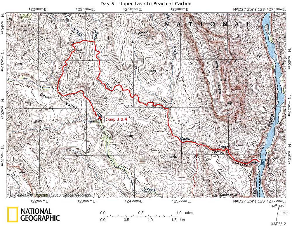
Day 5 October 24, 2011 Solo Exploration: Lava, Chuar, and Carbon |
 |
|
I was packed up and off at 7:50. At 8:20 I arrived at Chuar. I took a break there and filled up two quarts of water and drank the rest of the quart I started out with. I figured I probably wouldn’t find water until I got to the river. The hiking in Chuar was very easy – mostly sand and gravel streambed . In about 30 minutes I arrived at the place where I would leave the drainage and head over the saddle separating Chuar from West Fork of Carbon. Another break. Then the easy climb up to the saddle (or low ridge). It was only about 100 feet higher than Chuar, so I was at the top in no time. Even though the ridge was not high, the terrain in this area is very open, and even from a low vantage point you get fantastic views all around. From the ridge I could see Juno, Jupiter, Apollo, and Venus Temples; the North Rim near Cape Final; Chiavria Point; Chuar, Carbon, and Galeros Buttes; Lava/Chuar Hill; and Gunther Castle. Some of these were barely visible, so I may be mistaken about a few of them. I’m sure there were other named features that I didn’t recognize. I dropped down about 160 feet to the West Fork of Carbon. The hiking was easy on open, sloping hillsides. At 10:55 I arrived at the East Fork of Carbon. Glorious, easy hiking, with perfect weather. About 25 minutes before getting to the East Fork, I started noticing footprints. A little farther on I noticed fresh Tamarisk cuttings. I then remembered that Rondo had said that NPS rafts were tied up at Carbon beach, so I concluded that the NPS was out on a Tammy cutting mission. It really is a hopeless task, but I think their goals are limited to a few of the major side canyons of the Colorado. They will certainly never eliminate the Tammies from Grand Canyon, even if the release of Tammy-eating beetle is successful. It is less than a mile from East Fork of Carbon to the Butte Fault, where the canyon narrows and begins cutting through the Tapeats. This is also where you can easily hike over the low saddle and down into Lava (route marked with dashed red line on map above). The narrows of Carbon Creek are spectacular and long, but dry. This is the longest canyon in the Tapeats that I remember ever seeing. There was one significant, but easy bypass on creek right, and another spot where I had to remove my pack. I reached Carbon beach at 13:00. The river was even clearer now than it was a couple of days ago. I wandered around for about 15 minutes, looking for the best place for a boat to see me and still be able to pull in. Then I sat down and prepared for a long wait. Yippie! After only another 30 minutes, a private raft party pulled in. They set up tables for lunch and invited me to join them. The food was wonderful: fresh fruit, salads, roast beef sandwiches, etc. After lunch some of the group decided to hike up Carbon for a ways. After about an hour they returned, found a life vest for me, and we were on our way. I asked them if they would mind taking me all the way to Tanner beach. No problem. In about an hour I was at Tanner beach. They dropped me off at a secluded campsite I had scouted out a few days ago. I was now a day ahead of schedule, and would be camping off-permit tonight. I was supposed to be camping on the Unkar Use Zone, across the river from Tanner. I hate to camp off-permit, but I thought I had a reasonably good excuse. I hiked up the trail a little ways to retrieve my cache. It was in a steel mesh bag to protect it from rodents. I had hidden it in a crack on top of a large rock pile, and piled rocks on top of it to keep any potential large critters from hauling it away (Condors, Ravens, or Ringtails). Upon retrieving the cache, I was upset to find my food covered with small ants. Hundreds of them. They had bitten their way through the plastic bags and were eating my cookies and dehydrated chicken. Although I was looking forward to that particular dinner tonight, it wasn’t a big deal because I had an extra meal. |