|
Backpack from Supai to Great Thumb
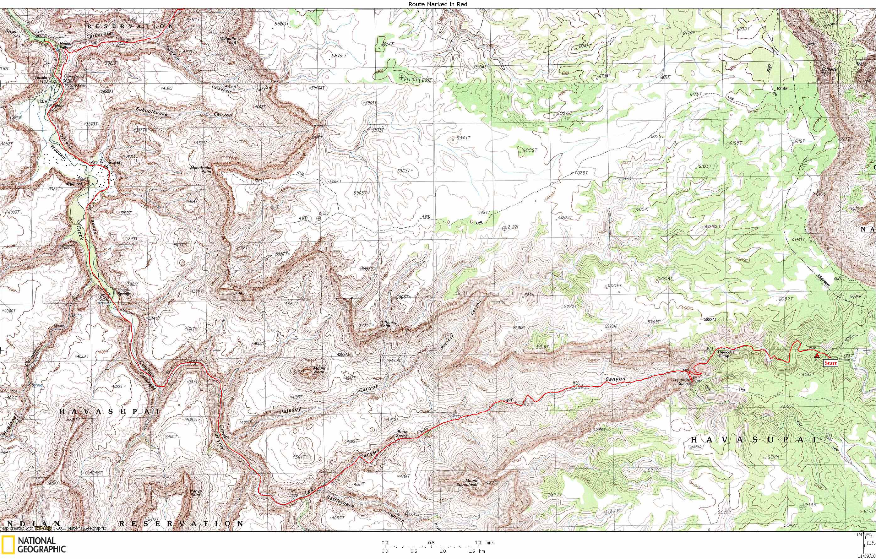
NOTE: Click on Hypertext to view photos. Three maps show the route:
Preface. In spite of my poor pre-hike conditioning,
the trip went mostly according to
plan. Which was (in summary): Drive out to Topocoba Trailhead
and drop off packs, then continue out to the start of the Great
Thumb Route at the end of Great Thumb Mesa. Leave car there and
ride mountain bikes back to Topocoba and camp for the night.
Hike to Supai the next day and spend a layover day there. Then
climb out of Havasu Canyon and onto the Esplanade via Carbonate
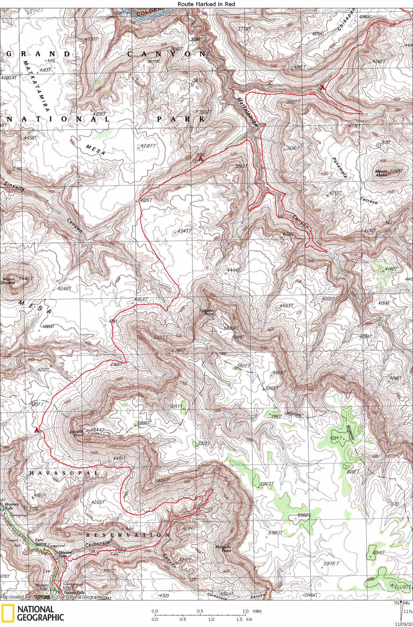
Canyon. Follow Sinyella (Sinyala on the older maps) fault
eastward, across Sinyella, Matkat, Olo, and 140-Mile canyons,
then climb back to car. Pick up bikes on the way back. Total
of 8 days (not counting mountain bike day).
I had originally planned to do this trip solo, but in January I decided it might be nice to have company. So I
asked two friends if they wanted
to go, figuring that most likely neither of them would be able
to make it. They both decided to go. Both have lots of
backpacking experience, but not much Canyon experience.
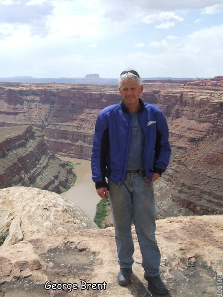
Trip members included
Bob Bordasch (Boulder, CO),
George Brant (Boulder, CO), and
Rich Magill (Ojai, CA).
March 30, 2001. George and I drove to the Canyon yesterday and met Rich this morning at the Grand Canyon airport. We then immediately headed for Great Thumb. We paid the $25 fee to the Havasupai. They didn't
ask us where we were going, so we didn't tell them. We dropped
off Rich and the packs near Topocoba Trailhead, and George and I
continued onto the Thumb. First obstacle was a gate. We had
been told that if the gate was locked, to just drive around it.
Well, there was a sturdy fence blocking the way. But the gate
was not locked and there were no "keep out" signs anywhere. So
we drove through he gate, re-latching it with a loop of wire. A
mile further we hit another gate -- same situation. The road
quickly became a real 4x4 road, and the next 15 miles was slow
going. When the road reached the rim overlooking 140-Mile
Canyon, we used binoculars to search for water. We spotted a
couple of potholes right where Bob Marley said some might be (in
the Esplanade sandstone on the west rim of 140-Mile). The views
off both sides of the Thumb were phenomenal. Toward the end the
road veers off the route shown on the 7.5-minute topo and
eventually peters out about 1/2 mile from the top of the Great
Thumb Route. I posted a note on the car window saying I was
hiking and would be back April 7. It took us almost two hours
to drive the 15 miles out, and about 2-1/2 hours to ride our
bikes back. We didn't see any vehicle tracks beyond the gate.
We reunited with Rich and set up camp in the trees a few hundred yards off the road. So far so good.
March 31, 2001. We followed the deteriorating road down the
drainage that turns into the Topocoba Trail. Again, no "keep
out" signs. In fact, no signs of any kind marking this
trailhead. The trail is very well constructed, especially
through the Coconino. It is easy to follow and well maintained.
We pumped some water from Topocoba Spring, and continued down
to Supai. We were encouraged to find plenty of water in the
creek bed for several miles near Burro Spring. I estimated the
distance to be 14 miles to Supai and another two miles to the
campground, for which I had a camping permit for two nights. We
were all really beat when we got to the campground, which was
really crowded, and very glad the next day was a layover day.
April 1, 2001. We awoke at 8:30 to a nearly empty campground.
Since neither George nor Rich had been to Havasu before, we
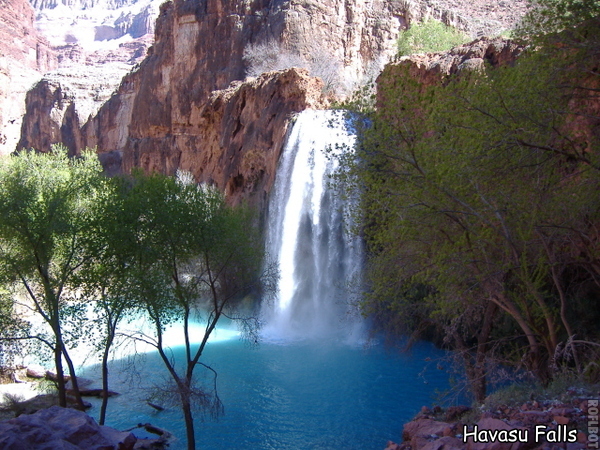
spent most of the day viewing Havasu Falls and Mooney Falls, swimming in the pools,
and relaxing in the shade. In the afternoon, Rich and I walked
up the trail into Carbonate, carrying some water to cache and
hoping to spot a short-cut exit route that Tom Martin had
suggested might be possible. We followed the trail to its end
at the head of the Redwall gorge, but we didn't see a route up
the left (North) wall that looked even remotely possible for
hikers. So we left two gallons of water and headed back to
camp.
April 2, 2001. We awoke at first light and were off by 7:00.
We were headed for the spring in the Sinyella fault ravine that
drains from the west into Sinyella Canyon. We greeted one hiker
just before we turned off into Carbonate, which would be the
last person we would see until passing through the Havasupai
"toll gate" again on April 7. After picking up our water we
each had about 6 liters each. Since Tom Martin had come down
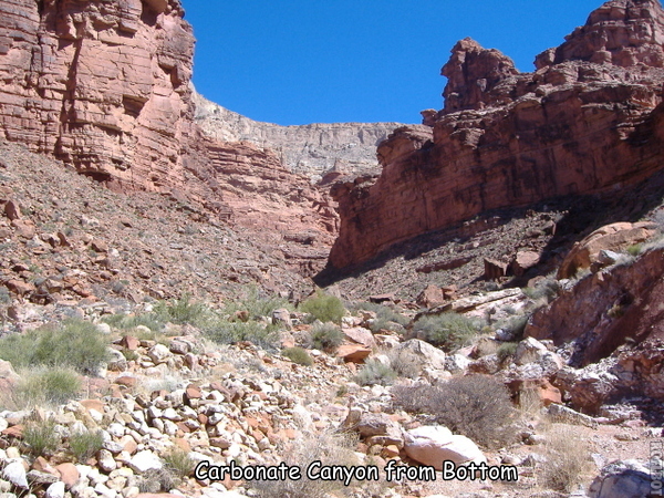
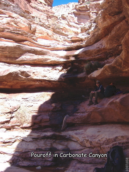
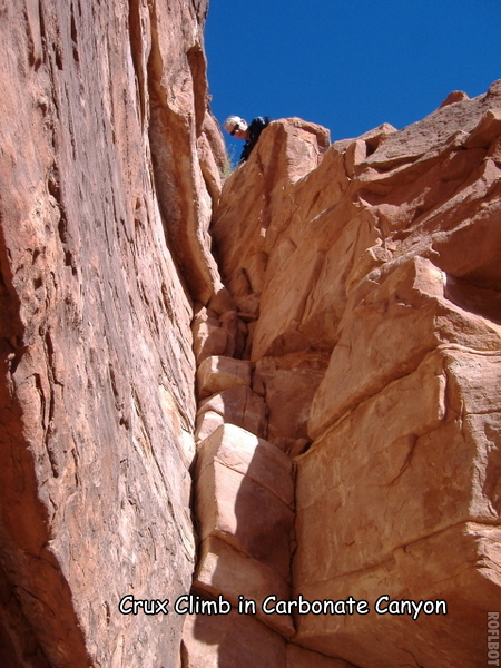
Carbonate, we knew the route would go. But I wasn't expecting
it to be so hard. There were at least a half dozen places where
we had to haul packs, and one place where we used webbing for a
belay. But there were pools of water most of the way up - and
occasionally even some small flows between pools. For the most part, Carbonate Canyon is pretty rugged. We finally
topped out on the Esplanade just before noon. Because we had
cool weather and had picked up more water on the way up, we
decided not to drop all the way down to the spring in Sinyella,
but to dry-camp on the Esplanade somewhere near the head of
Sinyella. After a few more hours of hiking on the Esplanade we
spotted a pothole. It was very odd since there were hundreds of
large depressions in the sandstone all over the area, but all
but this one were dry. And it was on a relative high point with
virtually no drainage into the pothole. So it must have
something to do with the porosity of the bottom of the tank.
Bob Marley noted this also, mentioning that these water sources
seemed to be near the mushroom or hamburger-shaped formations.
Anyway, we were very tired and decided to stop there for the
night. I suspect this pothole often has water. Its location is
N 36� 16' 31", W 112� 42' 6". It was a wonderful slickrock camp
with great views. But windy all night.
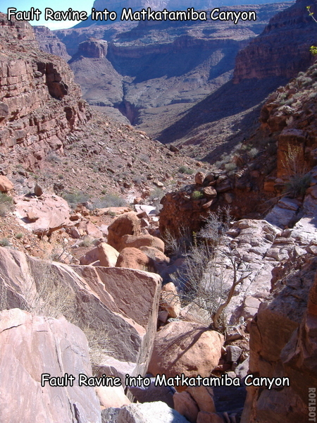
April 3, 2001. We were up and off by 7:30, heading for the
Sinyella fault ravine that drains into Matkat from the west.
The going was generally easy, but heading the canyons, even the
minor ones, was much more work than you would expect from
looking at the map. The views of Mount Sinyella were awesome. The route down into Matkat was steep and
loose in places, so we took our time. I think we had to lower
packs in a couple of places, but nothing major. About half way
down in the Supai we started finding water. We finally stopped
for the night most of the way down the ravine, where it starts
to level out above the Redwall. There was trickling water and
several good-sized pools.
April 4,2001. Today we were planning on heading around
Matkat on top of the Redwall, drop down into Matkat from the
east side, using the route described by Tom Martin in his book,
day-hike to the river and back, and camp somewhere on the above
the Redwall. We thought it would be a fairly easy day, so we
didn't get started until 8:30. We each carried two gallons of
water because we expected a dry camp. As it turned out, the
hiking along the Redwall to the head of Matkat was very slow
going, even though we found burro trails most of the way. We
spotted two groups of burros, totaling 8 individuals. We looked
for the route down on the west side that Harvey Butchart
describes, but found nothing obvious. We finally headed the
main arm of Matkat at 12:30. We probably could have dropped
down there (and should have), but we headed around to look for
Tom Martin's route down on the east side. Soon after heading
Matkat, we saw at least one broken down slope heading into
Matkat, but it was much too soon to be Tom's route. When we
finally got to the ravine that Tom has marked on his map, we
looked hard for a way down. We found nothing but vertical
limestone walls. We checked the ravines both up and down canyon
and still found nothing. We also could not see any way up
through the Supai at that location. So we concluded that Tom's
route was actually the one we had passed earlier, and much
closer to the head of Matkat than Tom indicated. By this time
it was almost 14:00. We were tired and discouraged, and didn't
think we would have enough time to hike back, find the route
down into Matkat, then hike to the river and back before dark.
This was a low point for me since I was really looking forward
to hiking down Matkat. I had hiked up Matkat to the "Patio"
once on a raft trip and was greatly impressed. So instead we
decided to press on. We headed the south fork of the east
branch of Matkat where we found a few pools and a small flow of
water. We stopped a little further on and camped on top of the
Redwall with a great view directly down the east arm of Matkat,
directly above where it forks.
Note: In March of 2007, George and I hiked from the village of Supai, up Carbonate, and on to Matkat. We camped on the Redwall at the head of the canyon. We tried to descend into Matkat from it's head, but we were soon stopped by huge pouroffs. So we walked back along the Redwall rim to look for the route down described by Butchart. This time we found it. It was a fairly easy hike to the canyon bottom.
April 5, 2001. From our camp we could see most of our route
up the NE arm of Matkat, to the point where it turns to the east
near the top. It didn't look hard, and it wasn't, but we did
have the usual garage-sized blocks to get around and pack
hauling in a few places. We found water in several places on
the way up. The route down into Olo was not too difficult,
similar to Matkat. Again we found water in the Supai. Quite a
lot this time. There were a few small cottonwoods, frogs, and
water flowing at perhaps a gallon per minute. Although not
finding water was a constant concern, we always found it in the
Supai, as Tom Martin predicted. As we were rounding the corner
of Olo above the Redwall we spotted another group of three
burros. I have mixed feelings about the burros. I suppose they
compete with the Bighorn sheep, but they sure make great trails.
They don't seem nearly as obnoxious to me as cattle. And they
sure seem to be in their element. The hike to the head of Olo
on the west side was slow going, but much shorter than Matkat.
The other side of Olo was much easier walking. We looked for
ways into Olo and found nothing. I think it was Tom Martin who
said that somehow sheep get into Olo, but I cannot imagine how
they do it. We camped at a spot on the Redwall overlooking the
two fault ravines as they enter the main drainage. Again a
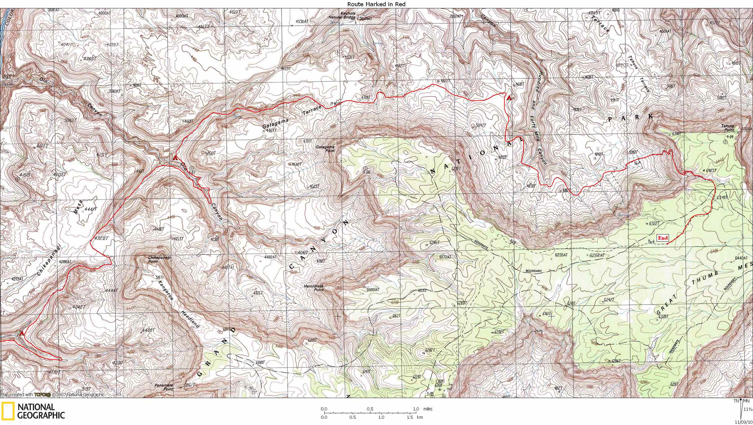
great camp, but windy and threatening rain.
April 6, 2001. It rained a little during the night, but not
enough to make any mud. Our destination for the day was
Marley's pothole that we spotted from the rim on the drive out.
We originally planned to drop down to the springs in 140-Mile
Canyon, but now it didn't seem worth the effort. Besides, I
like camping up on the Esplanade sandstone. So instead of
following the fault ravine straight up and out, we decided to
try the right (east) fork - the one that shows a spring on the
7.5-minute quad. This is a very pretty canyon, with a small
flow of water almost the whole way. It didn't seem like hard
hiking, but it took us a long time to climb out. We encountered
one difficult 12-foot pouroff near the top. Luckily in one spot
there was a small ledge half way up. I think this would have
been very difficult to do solo. From the top the hike over to
the pothole was pretty straightforward, but again heading the
branches of 140-Mile Canyon was more work than expected. The
pothole was easy to find. And since we also found the granaries
down below, we knew this was Marley's pothole. It was a very
nice camp which also provided some welcome shelter from the
wind.
April 7, 2001. We awoke early to a thickly overcast sky and
a strong, cold wind. We ate a cold breakfast and were on our
way by 6:15. We followed a burro trail all the way to the Great
Thumb Route. The trail contoured around on slickrock benches
well below the top of the Esplanade. It makes for easy hiking
and was incredibly beautiful. We found water in the drainage
coming down from the spring shown on the map at the base of the
Coconino. From there I expected the trail to greatly improve,
but our trail essentially ended there. There were lots of burro
(or perhaps horse) trails, but they were a braided mess that you
couldn't follow for long. The route went pretty much straight
up an alluvial fan that went all the way up through the
Coconino. It was exhausting, but went pretty fast. It was also
very cold, windy, and raining and/or snowing. The talus topped
out just above a cliff band in the Toroweap. Then the trail
reappeared and contoured south to a drainage, then up the
drainage to the top. As we were making a beeline compass heading
for our car, we noticed some fresh ORV tracks. I remember a
sinking feeling in my stomach, thinking of all the possible
states my car could be in. But my car was just as I left it,
with a gas can still on the ground next to it and ORV tracks
running right past. We were really cold by then, and glad to
get into the heated car. In two hours we were back at the
bikes, and in another two hours we were back in Tusayan.
I dropped off my friends at a motel - they were both flying out
the next day. George was flying to San
Francisco to pick up his girlfriend and then flying on to Hawaii
for a week of Pina Colatas on the beach. If it hadn't been for
that, we might have been able to stay one more day and explore
Matkatamiba. But it was a great trip. Next time I would like
to explore the upper branches of Matkat. I feel like I only
got a brief introduction to the area.
|